


FOUR-WEEK SUMMARY
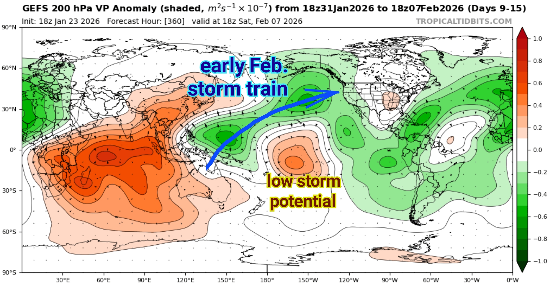
An ongoing, tropical, westerly wind burst (WWB) and subsequent rapid advance of the tropical Madden-Julian Oscillation (MJO) should begin to enhance precipitation potential (to some degree) across western Oregon within the next two weeks.
The state of Oregon has persistently had a very low snowpack (snow-water equivalent) for much of this winter. But, unfortunately, I think the prospect for more significant precipitation, including snowfall and atmospheric rivers, is not as likely until *maybe the third week of February.
Lately, a convergence of multiple factors has produced lots of computer model volatility beyond one week. This is why I always recommend looking at the larger global picture to get a better sense for what’s ahead.
There’s also increasing consensus for an upcoming stratospheric polar vortex (SPV) split induced by an ongoing three-stage SPV disruption. (see SPV Forecast)
FOUR-WEEK FORECAST
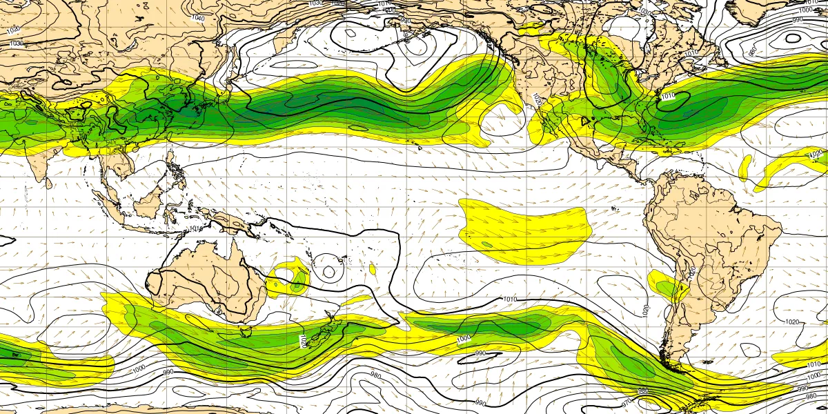
• (Tropospheric Jet Stream Winds)
The upshot here is that average temperatures and overall conditions will almost certainly begin to improve this coming week (as early as Mon–Wed.).
Wednesday, January 28 should be mostly dry with a high around 55°, although there’s also a roughly 30–40% chance of light showers, mainly overnight.
Thursday, Jan. 29 could reach 56–58° and should be mostly dry. But the latter half of this week will mark a slow transition towards a warmer, more showery pattern heading into next weekend.
During a brief dry warm spell in the first week of February, 3 to 5 days could reach 57–63°.
With strong high pressure over Alaska now getting squeezed southeast over the Pacific Northwest, conditions could generally remain mostly pleasant for several weeks, with the likely exception of February 5–20 (see next section).
By around February 20, I suspect the general pattern will begin to shift towards milder, more Spring-like weather.
POLAR VORTEX FORECAST
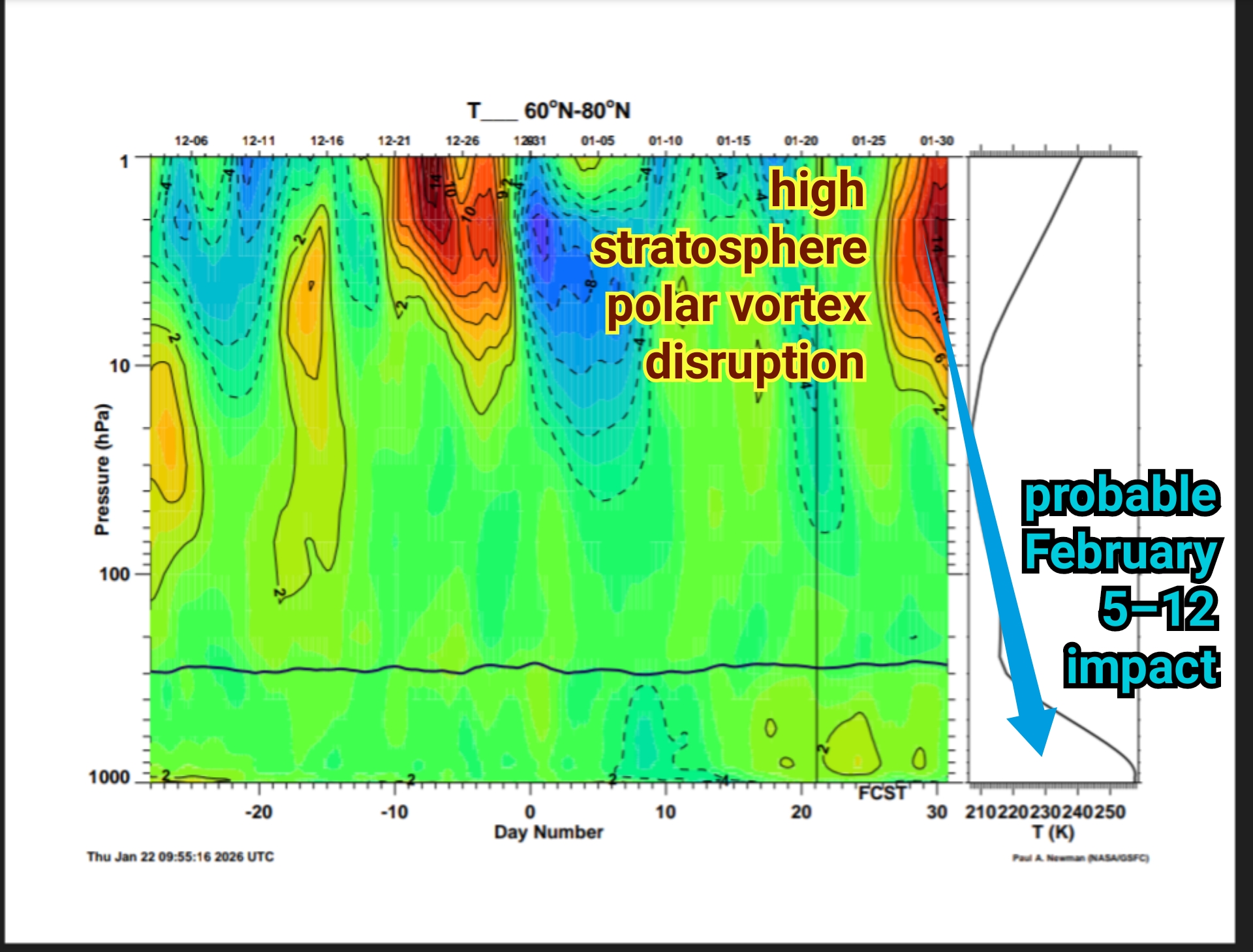
• (60–80° N Temperature column)
Currently, there is an ongoing polar vortex (SPV) disruption cycle, which may end up as our last strong disruption of the cold season.
This event is taking place in three stages, with a rapid strengthening phase currently, followed by a very strong second stage disruption of the (stratospheric) polar night jet stream this Wednesday, Jan. 28.
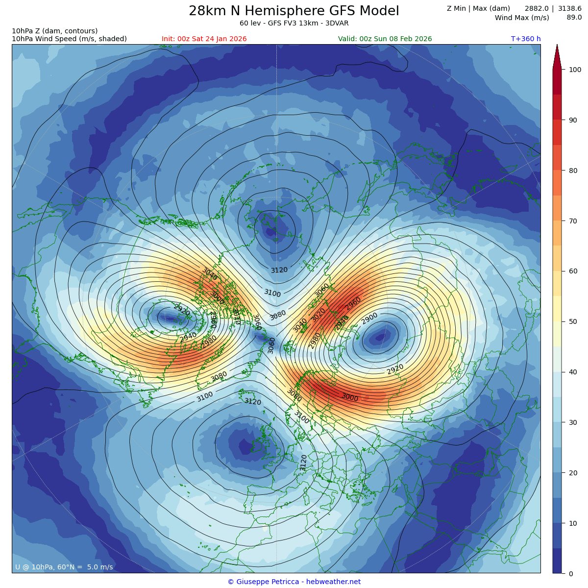
• (Feb. 7 GFS 10 hPa Winds)
The polar vortex is predicted to take on kind of a silly Ninja Turtle-like face around February 7th, due to an expected clean split of the vortex, but that split will not be CONFIRMED for at least a few more days.
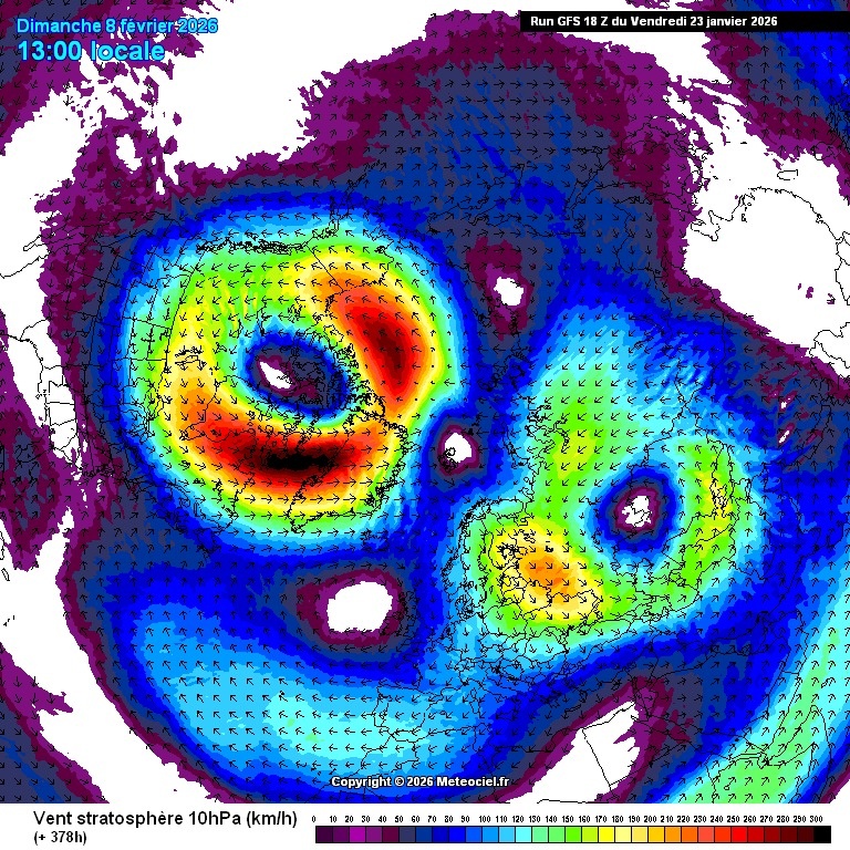
• (Feb. 8 GFS 10 hPa Winds)
IF IT DOES SPLIT, with one lobe predicted to settle over northern Canada, Oregon could potentially receive a very strong, fairly RAPID Arctic cold blast within 7–12 days after Jan. 28–30, so I would encourage folks to get prepared by February 4–6 for the first significant downstream impacts, which could last for a week, maybe longer.
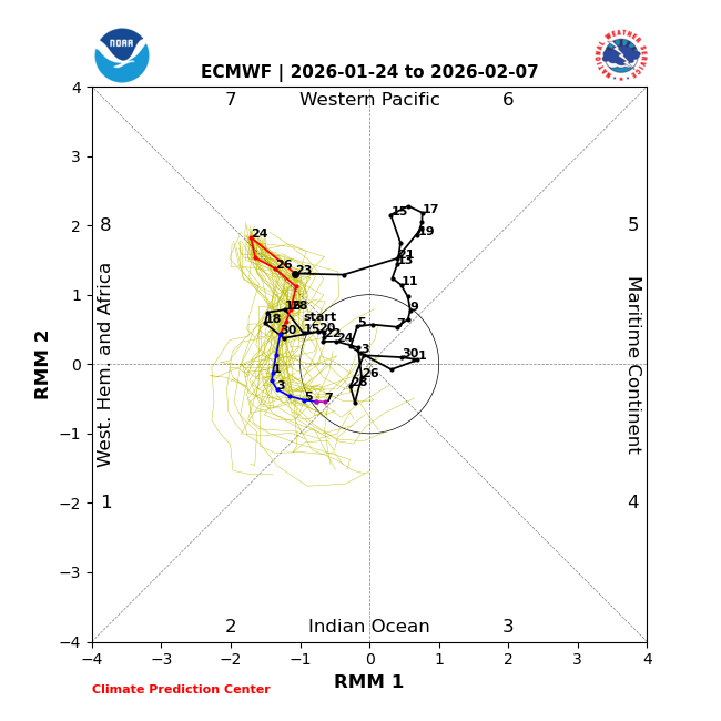
• (ECMWF MJO Chart)
As the MJO enters Phase 8 this week, this will probably add additional heat transport to the polar stratosphere, although average global winds (AAM) are really struggling to show much improvement for at least 3 weeks.
The MJO seems to collapse over the Indian Ocean in early February, but may re-strengthen near the end of February, while AAM shows signs of improving by then, as well.
How quickly and how strongly the SPV rebounds will help to determine how winter ends. I would not be surprised to see a few more periods of wintry weather between mid-February and mid-March.
For example, the third stage of the current SPV disruption looks to occur roughly around Feb. 3–5. Adding 12–15 days gets us to a possible SPV impact from Feb. 15–20.
ENSO OUTLOOK
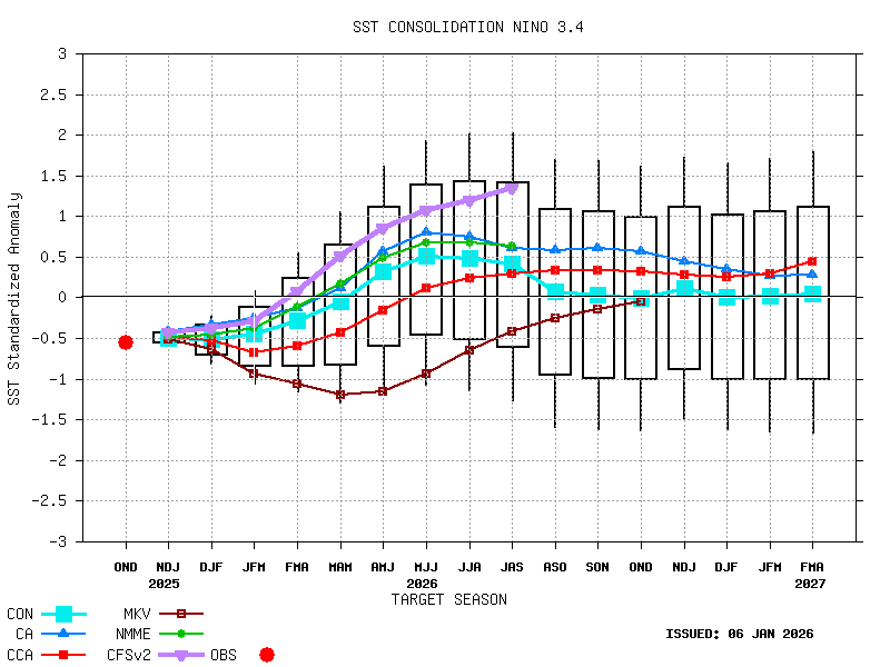
• (NIÑO 3.4 Sea Surface Temperature)
Tropical La Niña conditions are still hanging on, but getting close to ending. The El Niño-Southern Oscillation is strongly predicted to make a rapid transition by March into neutral ENSO conditions, followed by weak El Niño conditions by summer.
As far as I can tell, there is no model consensus on when this next El Niño will end or how strong it will get, but some models seem to suggest it could possibly end as early as the first half of 2027, which would be a huge relief for billions of people. I’ll look more closely at this next month.
Stay strong comrades!