
MARCH 29 DISSONANT WEATHER REPORT
QUICK SUMMARY
Temperatures will begin to drop this weekend. A strong atmospheric river arrives Tuesday night, March 31. Every other night this coming week could reach 29–38°, with patchy fog and frost on some nights.
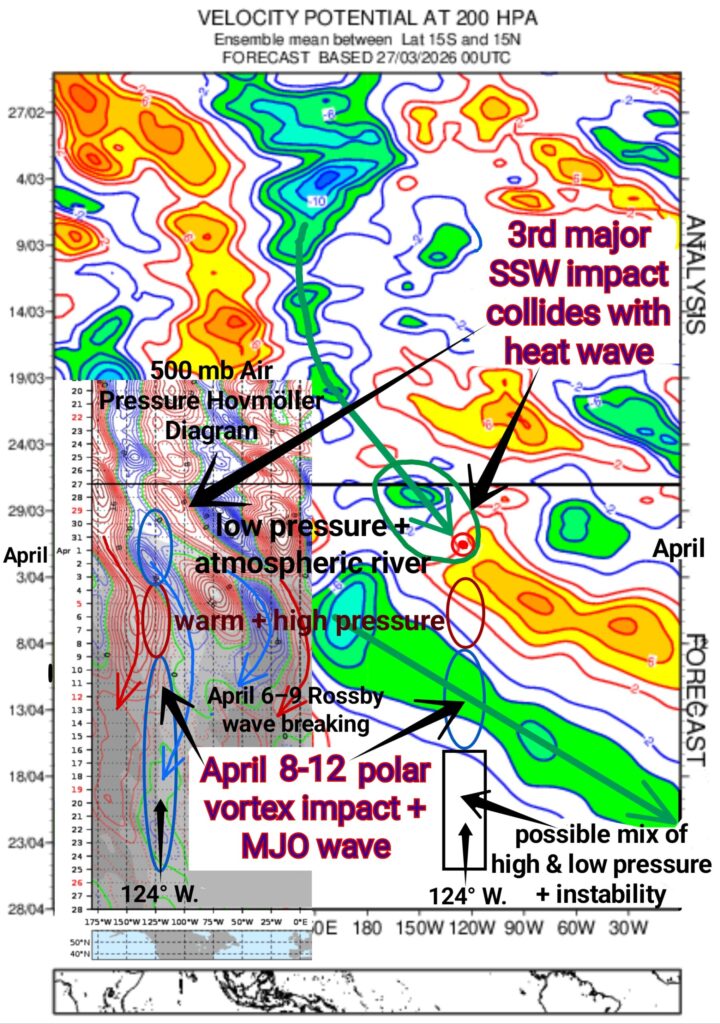
The first half of April will probably be noticeably more rainy than the second half, but uncertainty increases by mid-April, partly because of an uncertain forecast of average global wind speeds.
FOUR WEEK FORECAST
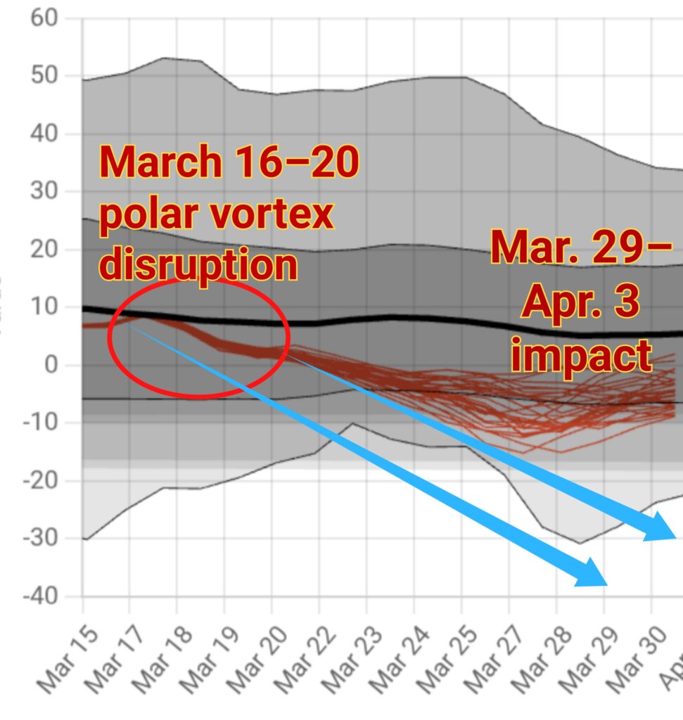
A March 16–20 stratospheric polar vortex (SPV) disruption will begin to impact western Oregon by Sunday evening, March 29, accompanied by a very weak frontal system. I’m giving Sunday evening a ~25% chance of brief light showers, but we might not get ANY precipitation.
That same polar vortex impact has the potential to maintain generally colder than average temperatures through the coming week, possibly keeping temperatures subdued through next Friday, maybe even Saturday, April 4.
*Every other night for the next week could reach 29–38°. Patchy fog and frost are likely on the coldest nights, especially on Monday night.
Similar to last time, this SPV disruption will also be interrupted by a robust atmospheric river expected to arrive late Tuesday night, March 31. Total 60-hour rainfall could range from 1.00–1.35 inches.
20–25+ mph wind gusts are likely across parts of the south Willamette Valley on Wednesday, April 1st. And the high central Oregon Cascades could receive around 12 inches of SNOW, maybe more, with at least 6 inches at the pass levels.
Post-frontal showers could linger through Thursday evening as the atmospheric river drops southeast, maintaining a colder, unsettled pattern overnight. Widely scattered showers should decrease late Thursday night into Friday morning, April 3, as high pressure and gradual clearing ensue.
A brief period of warmer, drier weather should begin next weekend, followed by Rossby wavebreaking and possibly quite a substantial period of colder, rainier weather.
Conditions will hopefully improve after April 15.
POLAR VORTEX FORECAST
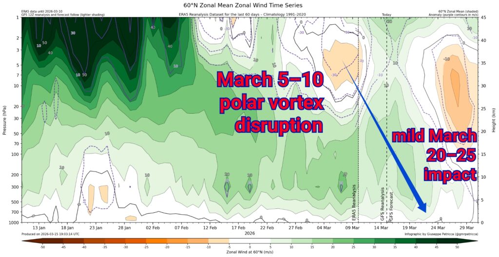
A March 5–12 polar vortex (SPV) disruption almost blended into the most recent SPV disruption from March 16–20— BOTH of which combined to produce our THIRD major sudden stratospheric warming (SSW) of the season around March 23.
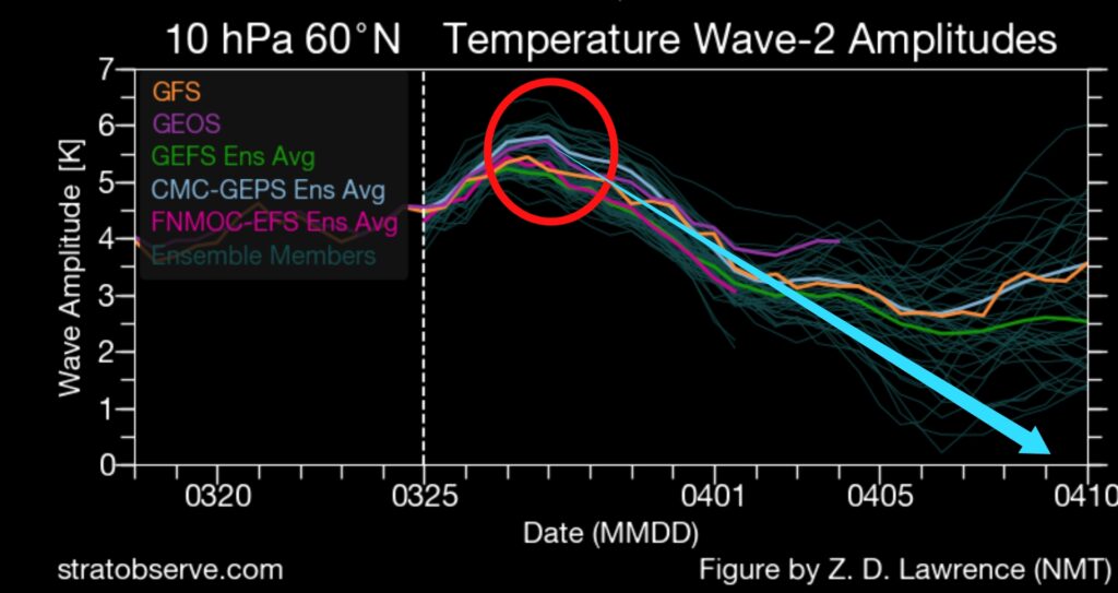
But, the SSW was/is mainly centered on March 26–29 as the polar night jet stream has reversed direction in the polar stratosphere (see 2nd chart). The high amplitude Wave-2 (meaning two waves) aspect is an indication that the SSW is also splitting the vortex.
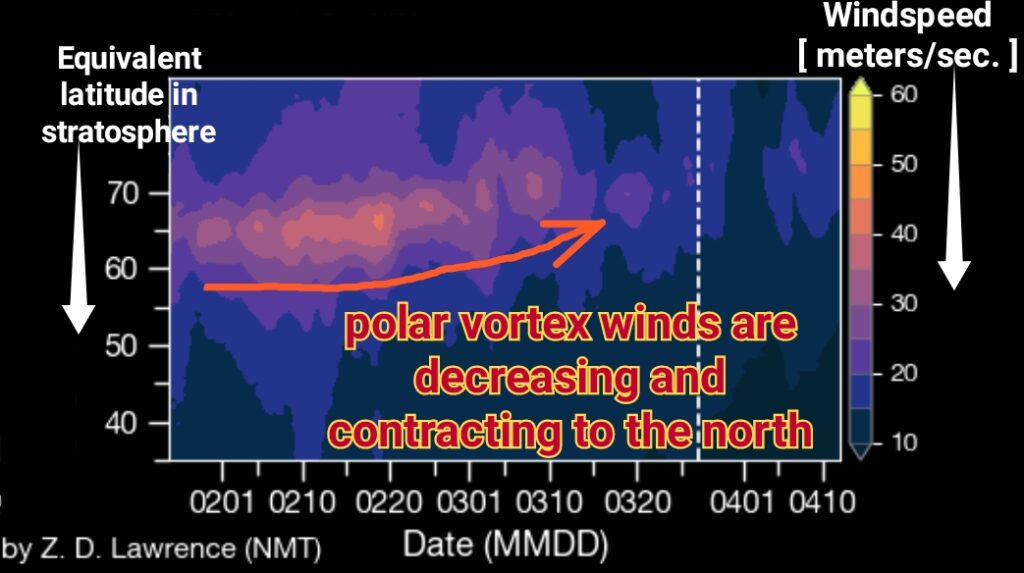
Adding 13–14 days to March 26–29 gets us to April 8–12, which will almost certainly be unusually cold for early April. But, the polar vortex is also getting weaker and smaller, and will probably undergo a Final Warming (warm season wind reversal) from April 4–10 (starting next weekend).
Any impacts on western Oregon would probably occur roughly in the April 16–25 timeframe and this could dovetail with a Pacific Jet Stream extension enhanced by east Asian mountain torque. My hunch is that period will see a mix of rain and sunny days, possibly with a chance for thunderstorms.
SEASONAL MJO and EL NIÑO FORECAST
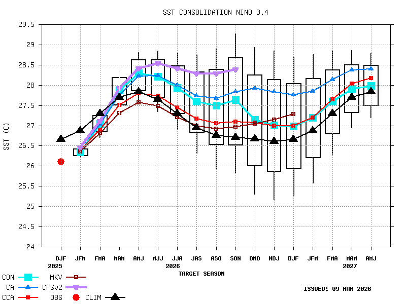
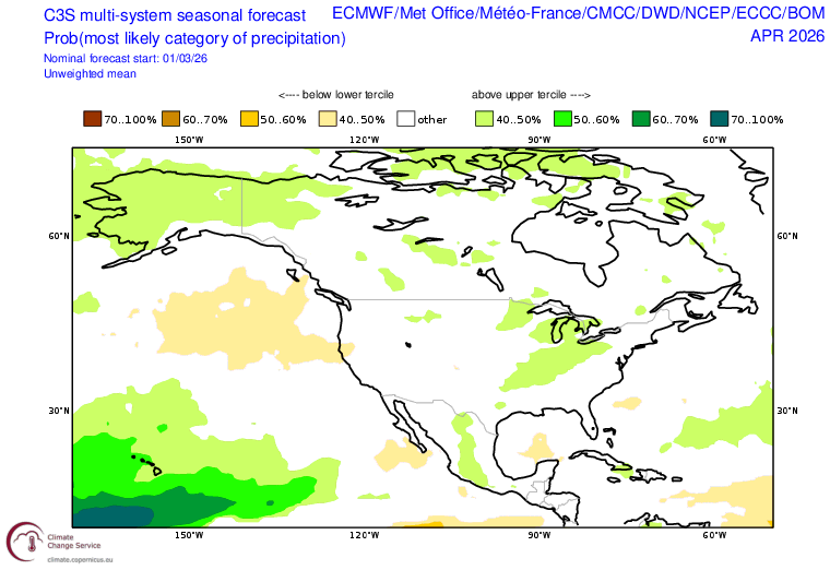
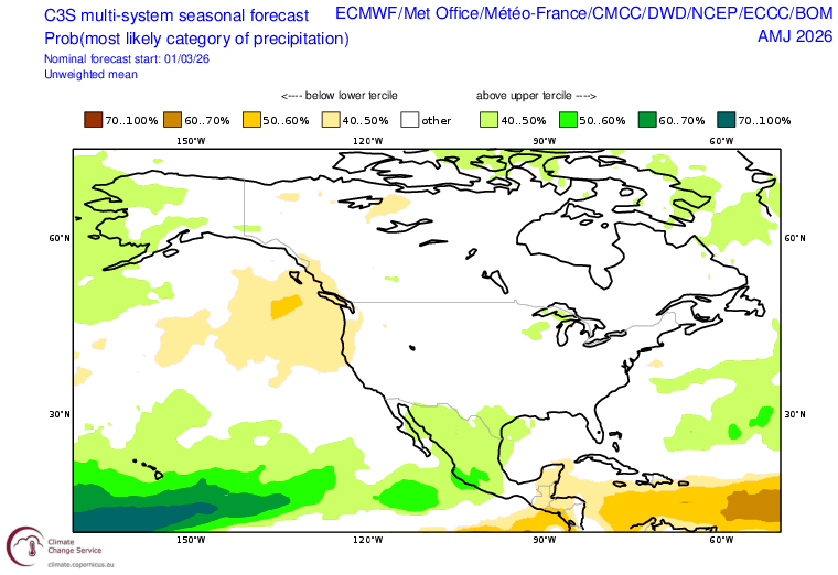
The signal for yet another strong El Niño (possibly a Super El Niño) continues to grow. El Niños typically depress rainfall over the Pacific Northwest, as can be seen in the monthly April and April-May-June C3S seasonal precipitation forecast.
The Madden-Julian Oscillation and associated equatorial Rossby wave pulse are expected to cause a “Westerly Wind Burst” (WWB) soon which will help push the tropical Pacific towards strong El Niño conditions this summer. Dual tropical cyclones are predicted to develop, thereby enhancing the upcoming WWB, which will also help strengthen the upcoming El Niño.
Lastly, as I discussed last month, the potential for a resurging El Niño is still being predicted for winter and early Spring 2027.
chart sources:
• (Chart #1) Center For Western Weather and Water Extremes (CW3E)
• (#2) European Center for Medium-Range Weather Forecasting
• (#3) Guiseppe Petricca at hebweather.net
• (#4) Guiseppe Petricca at hebweather.net
• (#5) stratobserve.com
• (#6) stratobserve.com
• (#7) Center For Western Weather and Water Extremes (CW3E)
• (#8) Center For Western Weather and Water Extremes (CW3E)
• (#9) Climate Prediction Center